Search This Blog

Showing posts with label Roadtrip. Show all posts

Wednesday, May 11, 2016

Day 2: Cannon Beach and Haystack Rock

Cannon Beach and Haystack Rock, Oregon
Oh Cannon Beach.  You beautiful thing you.  

Cannon Beach was a last minute add on for the trip, and a chance to skirt around the beaches of the Pacific Northwest.  Originally, I was going to cut right across from Portland straight to the coast and start in Tillamook.  After talking with Tyler, long term resident of Oregon and surfer of the coast, he recommended we start a little further North to see the beautiful (and popular) sights of Astoria and Cannon Beach.  I am so glad we added on this little "excursion" as it brought me to this beautiful spot, Cannon Beach. 

Monday, March 28, 2016

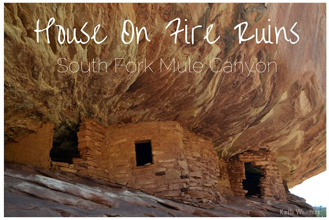
VIDEO: House On Fire Ruins - South Fork Mule Canyon

House On Fire Ruins

I had no idea that southeastern Utah was home to so many ancient ruins.  I wasn't really aware of Utah's ancient Pueblan history until my visit to Capitol Reef when I saw the petroglyphs carved into the walls.  While visiting Natural Bridges National Monument I saw the amazing horse collar ruins along the canyon walls.  A trip to Mule Canyon provided more amazing ruins in several different spots along canyon walls.  There aren't many places left where you can walk right up to a ruin (still intact in its natural location).  The most notable and famous set of ruins in this area is the House On Fire ruins in the South Fork of Mule Canyon, Cedar Mesa. 

Monday, March 21, 2016

Goosenecks State Park, Southeastern Utah

Goosenecks State Park
As far as campsites go, Goosenecks State Park is the bees knees.  

Amazing views, dispersed "camp where you want", basic amenities, dog-friendly, really affordable prices, and generally empty.  Those are some of the best qualities about a campground.

Some campgrounds are strict, quite expensive, and insanely crowded.  Usually, it's camp ONLY in designated spots, $25 a night and GOOD LUCK finding a spot if you don't show up mid-week.  I have had to sleep in my car parked next to the bathrooms in Arches National Park because I could not find an open campsite, even in the off-season, and overnight parking is only allowed in campgrounds.  I won't even go into the details of the pit toilets at popular campsites (you are welcome). 

Not only was I not able to pitch my tent I had so delicately packed along with its various necessities, but I still had to pay the $25 fee to "camp" there.  Thankfully I learned my lesson and avoid camping in the National Parks if I can.  If you read my post about all the BLM camping in Moab, it is quite easy to avoid those National Park campgrounds and find something better, less crowded, and for half the price.  

Friday, March 11, 2016

Camping Near Moab (with a Camping Checklist!)


Welcome to my Camping in Moab post


Let me start by saying Moab is one of my favorite places.  National Parks, amazing hiking and camping, world-class climbing, amazing mountain biking, nights spent under the desert sky and days spent on slick rock and red rock.  Moab just plain rocks (pun intended).  If you are heading to Moab you should spend a few days exploring this amazing playground for outdoor lovers.  So today, we are talking about camping in Moab.  Not only are you going to get all the information you need about the Camping in Moab, but you are also getting my (car) camping checklist.  Happy Freaking Friday Friends!

Moab is a camping mecca.  Moab offers a ton of camping options from campgrounds in the National Parks to your standard large commercial KOA style campgrounds.  However, I think some of the best sites our outside the National Parks, especially if you are okay with the "no frills" options.  For this post, we are going to focus on the Bureau of Land Management (BLM) campgrounds because if you chose to camp outside the National Parks, the fees are relatively cheaper, dog-friendly, less crowded, and with fewer restrictions.   So let's talk BLM camping areas.


The Bureau of Land Management (BLM) maintains 24 campgrounds in the Moab area.  BLM camp campsites are available on a first-come/first-served basis only meaning no reservations are accepted.  The good news is this gives you a higher chance of actually getting a campsite.  The bad news is it's a little tougher to plan.  You don't have to book 3 months out but yes, you need to be smart about when you show up, especially during the busy season and holiday weekends.

Along Highway 128

Along Highway 279
Along Highway 313
Along Kane Creek Road
Ken's Lake Area
Canyon Rims Recreation Area
Sand Flats Recreation Area
National Parks (not discussed here)
Reservable Group Campsites (reserved through recreation.gov.)

Dispersed Camping
Primitive Camping On Public Lands (free camping)

While the busy seasons like spring can be more crowded, if you go in the offseason, you may even get the entire campsite to yourself (we sure did!).   So now you know the basics, let's talk BLM camping areas, strategies for getting one, how much they cost, length of stays, and much more.

This link will bring you to the BLM campground website where you will see all of the campsites listed by area with information such as elevation, number of sites, amenities, etc.  Every site is listed out with all the information you need including mileage off the main access roads.  


These campgrounds are the walk-up tent site variety.  But if glamping or RVing is your thing, RV friendly campgrounds include Goose IslandBig BendHittle BottomGoldbarHorsethief, and Ken’s Lake. While nearly all of the sites are first come first serve, many of the campgrounds feature reservable group sites suitable for gatherings. 

Strategy for finding a campsite on Moab BLM
The campgrounds that are the nearest to Moab generally fill first, especially during April, May and October. For instance, if you want to choose one of the 11 BLM campgrounds along Highway 128, the first one, Goose Island, will usually fill first. . . then they will fill in progression up the highway, going away from Moab.  As campsites get more popular, they fill up faster and faster.  BLM includes this information on their website to help guide you in the process for finding a campsite in the first come first served process. 
  • Goose Island and Grandstaff campgrounds typically fill between 8:00-10:00 a.m. every day.
  • Big Bend and the surrounding campgrounds, Horsethief Campground on SR 128 and King's Bottom on Kane Creek typically fill by noon to mid-afternoon (sooner Fri-Sat). 
  • The Upper Colorado River (Hwy128) campgrounds usually fill in the late afternoons or evenings.
  • Ken's Lake Campground often fill mid- afternoon or early evening--sometimes earlier on busy weekends.
  • The Ledges campgrounds (5) typically do not fill except for busy holiday weekends due to the distance from Moab and graveled road (8-10 miles).
  • Windwhistle and Hatch Point Campgrounds (30+) miles south of Moab usually have sites available, except on holiday weekends. Hatch Point rarely fills, but requires driving 9 miles on a graveled road.

How long can you camp? Camping at all sites is limited to 14 days within a 30-day period.  The campsites are well kept, usually with vault toilets and a dumpster for garbage.  What are you missing?  A lot of the campgrounds do not have running water.  However, you are in Moab where there are plenty of stores to grab water, firewood, or whatever staples you may need. 


Find the interactive map here

The BLM Site did an amazing job of organizing all of this information for you, as well as maps, tables, and directions.  As someone who has spent a lot of time looking for campgrounds in certain areas of Utah before, this is amazing. I printed out this map (above) and the table (below) and headed off to Moab to find a campsite.  Not only can you see them all on the map, but you can get directions, the number of sites, and the cost of each site. And the BEST part yet?  Again, don't forget, they are first come first served.  Meaning you don't need to book a site 6 months in advance, you just need to show up early on a Friday morning!  Procrastinators unite. 

How much?
All individual sites: $15/night.  You pay at campground generally in a lock box leave a check style- cash or check only.

Amenities?
All BLM campgrounds and camping areas have vault toilets, fire rings and are open year round. Firewood gathering is not allowed and you will need to bring your own wood (you can find camp wood at all the convenience stores in Moab). NO water or electricity available in the campgrounds. Bring your own water and solar batteries/chargers if needed. 

Where else can I camp?
The Moab Field Office receives about 2 million visitors per year. Many of these visitors wish to camp, and many of these want to camp in close proximity to Moab. Because of the volume of visitors to the Moab area, the BLM has found it necessary to restrict camping to campgrounds or designated sites in our very popular areas. Campgrounds are found along Highways 128, 313 and 279, on the Kane Creek Road, at Ken's Lake, in the Canyon Rims Recreation Area, and in the Sand Flats Recreation Area. Click here for information on dispersed camping and restricted camping areas.

Primitive Camping On Public Lands (free camping) more info
Moab Area Camping Restrictions  Camping is restricted to designated sites in the areas shown on the map above. These sites are marked with a brown post and a tent symbol. These designated sites are free, but no facilities are provided. -  Campers are required to carry out all garbage, including solid human waste and toilet paper. There is no wood cutting or collection allowed. **Campers are required to possess, set up and use portable toilets. Campers may not bury or leave solid human body waste and toilet paper. The disposal of solid human waste off public land is required. 


Primitive Camping Areas
-Dubinky Well Road - 12 sites on the east side of the road
-Gemini Bridges Road - 6 campsites located in Bride Canyon. 
-Cotter Mine Road- 10 sites located just off HWY 191 and north of SR 313
-Dripping Springs Area - 6 large campsites near Tenmile Wash
-Black Ridge Area - 6 sites located in the camping area.
-Picture Frame Arch Area - 4 sites located in the Behind the Rocks area located six miles southwest from Moab off Hwy. 191

There are several areas in which no sites are designated and camping is not allowed. The Shafer Basin, which forms the viewshed of Dead Horse Point State Park and is important bighorn sheep habitat, has no sites. Long Canyon, which is subject to extreme flooding and is also important bighorn habitat, has no sites. No camping is allowed in the Mill Creek area immediately east of the city of Moab, or on the west side of Spanish Valley. No camping is allowed within one mile of developed recreation sites in the Canyon Rims Recreation Area.


In addition to these, Moab also has 13 commercial campgrounds:   http://discovermoab.com/campgrounds_private.htm


We ended up camping at Jaycee Park along Potash Road (Highway 279). Even if you don't end up camping along this road, it is worth it for the scenic drive.  On one side, you have the beautiful winding Colorado River and on the other side, you have a wall of rock known as "Wall Street", a popular area with the climbers (apparently Moab offers some of the best climbing in the world).  Driving down the road, we saw a lot of climbers on the side of the road tackling Wall Street. 


We arrived at our campsite, Jaycee Park.  It was the first campground off of Potash Road and had seven sites.  It was located right along the road on the opposite side of the Colorado River. There was a bulletin board with instructions to pay, a clean vault toilet, a dumpster for garbage, and each campsite had a picnic table and a fire ring with a grill.  There was only one other site reserved so we almost had the entire campground to ourselves. 


Bring a check or cash for the camping fee.  It was $15 per night, where you put the money in an envelope, dropped it into the slot, and left the ticket stub on the clip of your campsite.  There was no running water but we had enough that it was not an issue. 


And now, the list I use for every camping trip.  This is for car camping obviously as you are not going to backpack or hike all of this in.  For a great backpacking list, check out Girl on a Hike's complete list here.  But if you are car camping (as I usually am) then this is a great list to have on hand while packing up the car.  If you have any suggestions or additions to the list, feel free to leave them in the comments and I will keep updating the list.   You can even grab my printable PDF here.

printable PDF here

While In Moab... 


Hike Nego Bills Canyon (Dog Friendly)
Hike Dead Horse Point State Park (Dog Friendly)
Hike Corona and Bowtie Arch (Dog Friendly)
Mountain Bike Lower Monitor and Merrimack (Dog Friendly)
Mountain Bike Navajo Rocks  (Dog Friendly)
Hike Mill Creek Canyon and Waterfall  ((Dog Friendly)


Wednesday, March 9, 2016

Lower Monitor and Merrimac Mountain Biking Trail - Moab, Utah


I was looking for some beginner/intermediate trails for a weekend spent hiking and mountain biking in Moab.  I have seen friends come back bloodied and bruised after tackling some of Moab's famous and challenging trails like Whole Enchilada.  
I wanted the opposite of that.  

Monday, March 7, 2016

Dog Friendly! Corona and Bowtie Arch - Moab, Utah


Delicate Arch is always in the spotlight when it comes to Moab's arches. But I am here to tell you there are a few gorgeous and equally as impressive Arches outside of the National Park's borders.  


What is the advantage of visiting Moab 
and hiking outside of the National Parks?  

Well, for starters, it is free.  The National Parks are about $25 a car to enter, where as hikes on BLM land are free and open to the public.  Secondly, while the National Parks do not allow dogs anywhere on their trails (only in parking lots and paved roads), hikes outside the park are dog friendly. Fido is welcome on BLM land and State Parks.   And lastly (and most importantly) you can avoid the mobs and crowds that flea to our beautiful National Parks.  Hiking trails outside the park are deserted compared to the high number of visitors on the trails at National Parks.  While everyone heads to Delicate Arch, head to Corona Arch. 

Dogs, free, and less people.  Have I convinced you yet?