Search This Blog

Showing posts with label Zion. Show all posts

Monday, April 6, 2015

Driving Routes Zion National Park and Weekend Itinerary

Hello world! On our way to Zion National Park! 

Some funny facts: getting our time zones straight....


Weekend itinerary:
Friday:  4+ hours from Salt Lake City to Zion National Park
Hiking all day in Zion and camping in Zion Friday Night

Both routes clock at 308 miles.  
4 h 19 m or 4 h 34 m

Friday morning, we packed up the car around 5:30 am and were out the door by 6 am.  The plan was to head South down I-15 and in Southern Utah cut East and come into the park from the opposite end.  This was a good way to drive a “loop” around Zion instead of heading straight down 15,up the Canyon road, and back the way we came. 

(Take the route not highlighted- coming into Zion from the east and through the tunnel). 
This allowed us to come through the Zion/Mount Carmel Tunnel, drive up and down the National Park Canyon Road, and then out a different way we came.  I think the mileage is pretty similar for both routes and may add a little extra time (worth it!).  We got to Zion around 11:00 am after a stop or two along the route.  It was a gorgeous sunny day in Southern Utah.


Zion backcountry map


Source

Saturday:  Morning in Zion
and head south to Vegas. 


Head to Lake Las Vegas-  
Check in at the Westin.
Spend the day by the pool!
Night in Vegas? 

Sunday:  Hang around Vegas, slowly head back up to Utah
Long run 11 miles somewhere along the way home 


Tuesday, March 31, 2015

Kolob Canyon, Zion National Park


Heading to Vegas?  Maybe even traveling that stretch between Vegas and Salt Lake City?  Heading towards Zoin National Park?  Then I have the perfect stop for you.  I bet you didnt know about Kolob Canyons, and I'm sure you didnt know this park is actually a part of Zion National Park.  It is the northwestern section that is accessible off exit 40 on I-15 (READ: you cannot access this section through the Main Zion entrance).  It is the beautiful, quiet part of Zion that no one really talks about... but should.

Passing through Arizona on the way home

The park is literally right off the highway- making it an awesome pit stop for the 6 hour drive from Vegas to Salt Lake City.  You will see the signs right off the highway and it is about a minute drive from the highway.  Don’t forget, this is a National Park so you will be responsible for the $25 park fee (or your yearly park pass).  If you were at Zion within 7 days, the pass you bought there will work here too. 


Kolob Canyons are 40 miles north of Zion Canyon and 17 miles south of Cedar City. The main scenic road through the park is a five-mile scenic drive along the Kolob Canyons Road.  Here you can view the crimson canyons and gain access to various trails and scenic viewpoints.

Familiar red roads of Zion National Park
Kolob Canyons

Kolob Canyons, Zion National Park

In the northwest corner of the park, narrow parallel box canyons are cut into the western edge of the Colorado Plateau, forming the peaks and 2,000 foot cliff walls. 

Kolob Canyons, Zion National Park
Trails at Kolob Canyons, Zion National Park
The trails are really easy to follow.  
We did the 2 mile out and back trail at the end of the road winding through the park. 

Trails at Kolob Canyons, Zion National Park

Viewpoint from the end of the trail, Kolob Canyons, Zion National Park
Kolob Canyons, Zion National Park
Snow covered mountains, views from Kolob Canyons, Zion National Park
This was a gorgeous little spot and a great pit stop to stretch out legs and see another section of Zion.  It is right off the highway, making it a perfect pit stop for anyone traveling along I-15.  If you are visiting the main Zion Canyon and heading north after, add Kolob Canyons to your list.  

Thursday, March 19, 2015

Riverside Walk, Entrance to The Narrows, Zion National Park


Riverside Walk / Entrance to The Narrows Zion National Park, Utah 


Riverside Walk, Zion National Park, Utah 


The Riverside Walk Trail was a great way to end our day at Zion National Park in Southern Utah.  Riverside Walk is the 2 mile out and back paved trail that leads to the entrance of The Narrows.  The trail head is at the Temple of Sinawava, which is at the very end of the Zion Canyon Scenic Drive (the 6 mile road through the park where are the trail heads are).  

Riverside Walk Map, Zion National Park 


Riverside Walk, Zion National Park 

The paved trail is one mile out to the end, following the Virgin River to the start of The Narrows.  There are portions where you can leave the paved trail and walk right along the river with your toes in the sand.  It is much cooler here than the other sections of the park and the water is quite cold this time of year.  

Virgin River, Riverside Walk, Zion National Park

Riverside Walk, Zion National Park

This is a gorgeous trail for all types of hikers, and a great option for anyone looking for an easy hike on a paved trail with gorgeous views along the Virgin River. 


Riverside Walk, Zion National Park

Riverside Walk, Zion National Park

Riverside Walk, Zion National Park

Virgin River, Riverside Walk, Zion National Park

Virgin River, Riverside Walk, Zion National Park

We started this trail at around 5pm and saw a ton of hikers, a bunch walking back from The Narrows in their dry suits and hiking sticks.  Although hiking The Narrows in the winter requires a $40 dry suit rental, you get to enjoy a less crowded hike in one of the most beautiful and popular sections of the park.  I fully intend to head back to Zion to hike the famous Narrows and can’t wait to tell you all about it then. 

Hikers in dry suits at the entrance to The Narrows, Zion National Park

Hikers in dry suits at the entrance to The Narrows, Zion National Park

The Narrows starts right here, where the Riverside Trail abruptly ends and the only way to continue is, you guessed it, right through the river.  


This is how I spend most trips, with a Go Pro or camera in front of my face. 

Riverside Walk, Zion National Park

If trudging through the river for 8-12 hours, or even over night isn't your definition of the best hike ever, or the weather won’t allow, the Riverside Walk is a great way to see the beautiful Virgin River and the opening of The Narrows.  


Wednesday, March 18, 2015

Angels Landing Trail, Zion National Park

Angels Landing Trail
Zion National Park, Utah 

5 Miles round trip to the edge of Angels Landing
4 Miles round trip to Scouts Lookout (before the chains)


Trail head: Grotto Picnic Area 

Angels Landing Rock Formation: 1,488-foot (454 m) tall

Elevation at the top of Angels Landing: 5,790 feet


View of Angels Landing from the parking lot, Zion National Park

Angel’s Landing is one of the most famous and iconic hikes in Zion National Park. Angels Landing and The Narrows are usually the most talked about hikes, and find their way to the top of everyone’s MUST Hike List. 

Why? 
The challenge.
 The first 2 miles of the trail are hard work, but the last 1/2 a mile is for thrill junkies only.

Angel’s Landing is the high, steep cliff face overlooking Zion Canyon. "While exploring what was to be present day Zion in 1916, Fredrick Fisher proclaimed “only an angel could land on it” and consequently the monolith was named Angel’s Landing" Source


Virgin River, Zion National Park
To start, you will cross a bridge over the river, and head up the paved trails.  The trail starts out  relatively flat but starts to switch back up the steep trail quickly.

Insanely gorgeous view down the canyon from the Angels Landing Trail, Zion National Park

Soon you are rewarded with this view down the canyon. I could spend the day here it was so insanely beautiful. The trail will head up some steep switchbacks until you reach Refrigerator Canyon. This canyon is a nice flat(ish) paved trail, between the canyons where the temperature drops, and the shade is a nice relief. 


 After leaving this canyon, you head up again and approach Walter’s Wiggles, the very steep switchbacks leading to Scouts Lookout and the section of the trail where the chains start. Walters Wiggles are a serious glute workout (21 switchbacks), I promise! After Walters Wiggles, you reach the start of Scouts Lookout. Here you will find some bathrooms, as well as a lot of people waiting for their friends and loved ones to make it back from "the chains".


Refrigerator Canyon, Zion National Park


Walters Wiggles, Angels Landing Trail, Zion National Park


This is the spot where I enjoyed a cold beer, and watched the hikers leave nervous and excited, and come back either feeling accomplished or in tears (a whole lotta tears).
First views of the chain section of Angels Landing Trail, Zion National Park
The hikes claim to fame is the last half a mile of the hike, where the paved trail ends, and “the chains” begin. The last half mile of the hike is up the rocky spine of Angels Landing. A set of poles and chains runs through the middle of this half mile stretch.


The easy beginning of the chains on the Angels Landing Trail, Zion National Park

If you are not a fan of heights like me, you can still enjoy a hike to Angels landing up to the point where the chains start, known as Scouts Lookout or “Quitters Corner”. The trail up until this point is a challenge, with steep climbs and large drop offs, but with the actual comfort of the trail. 
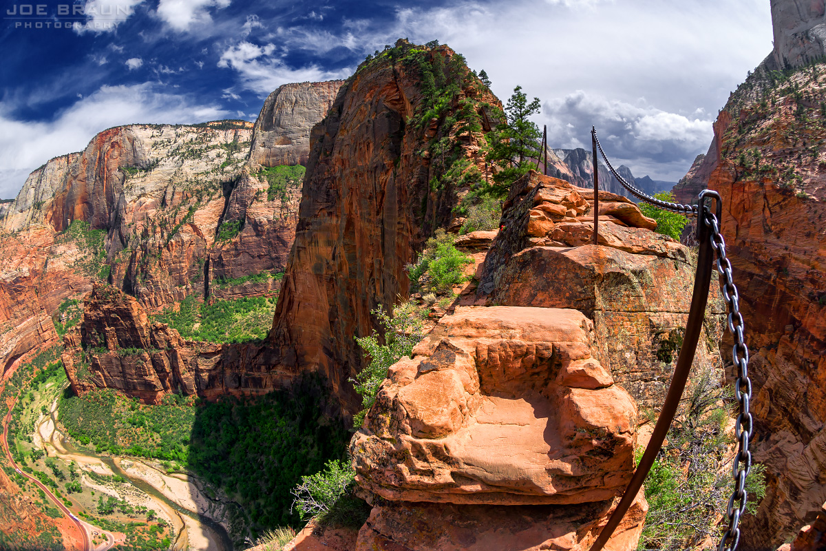
Scary part of Angels Landing I did not make it to- "Leap Of Faith"- 1000' drops on a 2' trail
Angels Landing photo (Zion National Park) -- © 2007 Joe Braun Photography
The view from the very edge of Angels Landing. 


The trail gets as narrow as 2' in some spots, with 1,000’ drops on each side. The only thing keeping you plummeting to your death is steady foot work and a firm grasp of the chain. Not only is the trail narrow, with 1,000’ drops, but it is a verrrry popular trail with a lot of traffic, and a lot of people pulling on that chain in front of you and behind you. 


No. Thank. You. There have been a few deaths at this section of the park. But when you compare it to the thousands of people who use this trail, it really isn't common. Just make sure you have some steady foot work. If you have any fear of heights, they recommend you stop at Scouts Lookout.  Eight Reasons you shouldn't hike Angels Landing.


Warning signs at Angels Landing Trail, Zion National Park

Canyon Views, Angels Landing Trail, Zion National Park
If this does not sound like your cup of tea, don’t worry, you can enjoy the hike up until this point. The views are phenomenal along the entire hike. Do not let this trails history/talk scare you away. The views are spectacular and you can still experience amazing views up until Scouts Lookout.
Heading back down the Angels Landing Trail, Angels Landing Trail, Zion National Park
          
Steep drops and gorgeous views, Angels Landing Trail, Zion National Park

Canyon Views, Angels Landing Trail, Zion National Park
Steep climb on the Angels Landing Trail, Zion National Park
End of the trail, the Virgin River, Angels Landing Trail, Zion National Park
The hike back down is gorgeous, with more astonishing views. If you only make it to quitter corner, you are still enjoying a gorgeous 4 mile hike, with some serious incline and view for days. Power to you if you make it all the way to the landing, and a high five if you only make it to Quitters Corner like me ;)

Avoid this trail in icy conditions, and in the summer, 
make sure you start before the heat sets in. Good Luck!