
Utah's Scenic Byway 12 (Highway 12)
"The All-American Road"

There is something pretty dreamy about wandering through the American West. So often, we get hung up on dreams of traveling to Europe, or beaches of Barbados. While all that is lovely, sometimes we forget how much beauty we have right here in the states.
Driving Utah's Scenic Byway 12 (commonly referred to as "Highway 12 -A Journey Through Time Scenic Byway") is a road, yet a destination all on its own. While this expanse of road between Capitol Reef National Park and Bryce Canyon National Park is not designated as a National "Park" in it self, it travels through National Forests, National Monuments, State Parks, and some of the cutest towns. This gorgeous drive is also a connection between two parks, which is just what we had planned to do. After a lovely day in Capitol Reef, we had plans to stop along a few points of Highway 12 on our way to Bryce Canyon.
Driving Utah's Scenic Byway 12 (commonly referred to as "Highway 12 -A Journey Through Time Scenic Byway") is a road, yet a destination all on its own. While this expanse of road between Capitol Reef National Park and Bryce Canyon National Park is not designated as a National "Park" in it self, it travels through National Forests, National Monuments, State Parks, and some of the cutest towns. This gorgeous drive is also a connection between two parks, which is just what we had planned to do. After a lovely day in Capitol Reef, we had plans to stop along a few points of Highway 12 on our way to Bryce Canyon.

This drive can be found on every RVers dream list, and in nearly every book about scenic drives. It is historic, iconic, all american road tripping. And this is just what I intended to do with my time out west. It is one of the most beautiful and diverse places I have ever seen. 124 miles, and about 2.5 hours without stopping. Leave yourself plenty of time to get out and explore along Highway 12.
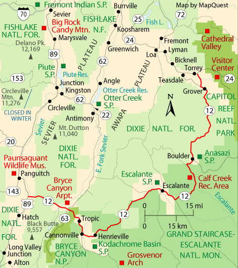
Proceeding west to east for 122 miles (nearly 200 km), the highway technically "starts" by Byrce, south of Panguitch at an intersection with US-89, crosses part of Dixie National Forest and Bryce Canyon National Park, continues through the small towns of Tropic, Cannonville, and Henrieville. It crosses various parts of Grand Staircase-Escalante National Monument(GS-ENM), continues northeast through Escalante and over the Escalante River, then north through more of GS-ENM, Boulder, the Aquarius Plateau, Grover, ending in Torrey at an intersection with SR-24, five miles (8 km) west of Capitol Reef National Park. The 30-mile (48 km) long portion of the highway that ascends and descends Boulder Mountain on the Aquarius Plateau is known as Boulder Mountain Highway. Source
122 miles of scenic Utah is the background for your drive to the next park. Traveling through iconic landmarks stopping at some breathtaking scenic overviews.
Buckle up, we are leaving Capitol Reef and traveling through time through the American West.

Once you hop onto Highway 12, there is a visitor center you can stop in for maps, and to ask any questions. Shortly after leaving, you will enter a few tiny towns and then you are back into National Forest Land, the Dixie National Forest. As it winds along the east flanks of Boulder Mountain,
Scenic Byway 12 climbs to an altitude of more than
9,000 feet and offers views of the rugged,
rainbow-hued landscape below .
The FIRST thing you will notice about Dixie National Forest is all of the cows. Yes, Cows. You just left the sandstone of Capitol Reef, and now you are what feels like deep in a forest surrounded by so many cows. Turns out, the forest is an open range for cattle. You will find cows in the road, on the side of the road, on the cliffs, in the meadows, cows crossing the road... cows everywhere. They seem pretty used to the tourists driving through their territory and just sort of stare back at you. We stopped a few times to photograph these funny cows ALL over the forest. Make sure you drive slow and keep your eyes peeled for a casual cow crossing the road.


The views in this area were the perfect fall treat. The aspens were all turning, and fall on Highway 12 was bursting with fall foliage. This has to be the best time to drive Highway 12. Homestead Overlook provides dramatic panoramic
views from a 9,400-foot-high vantage point. From this
lookout you can see the five peaks of the Henry
Mountains to the east, the magenta wedge of the
Waterpocket Fold below, and the striated face of the
Kaiparowits Plateau to the west.


Just traveling through iconic Highway 12 in the fall. ;)

After leaving Dixie National Forest and the cows behind, you enter the town of Boulder and continue on to the internationally famous stretch of byway known
as “The Hogback.”. Highway 12 takes you along the thin
razorback ridge of slickrock in this area, with steep drops on either side to the winding creeks and canyons below. You will be driving slow through this winding ribbon of road, but the views and vistas are incredible.


After leaving the hogback, you will come across the Calf Creek Recreation Area. This is the popular campsite and hike to Lower Calf Creek Falls. All of this area is dog friendly and this is where we stopped for a hike with Olive. This 6 miles trail was so amazing that it is getting its own post Friday. Hiking in the heart of the Grand Staircase Escalante National Monument is a perfect way to stretch your legs during the drive. We were planning on camping here but the small 15 campsite area was full. Onward.

Continue on and you will see an overlook for the Canyons by the Escalante River. Gorgeous rock with deep canyons seen for miles and miles into the horizon. "Boynton Overlook gives visitors a bird’s-eye view of the
riparian area along the twisting Escalante River. Flowing
water and native vegetation offer ideal habitat for small
birds and animals, including river otters which were
reintroduced here in 2005.
The overlook was named for John Boynton, a
cattleman caught in a lawless confrontation involving a
disagreement over livestock and a murder in 1878. Today,
the overlook serves as a welcome stop to experience the
sights and sounds of the Escalante River Canyons".
We even passed this amazing coffee shop (Kiva Coffee) nestled into the ridge of the GSENM. Some of the towns, stores and stops along this road are essential to get the real "Utah" experience. After stopping in for gas, we overheard the store owner chatting with a local about "that darn cow getting stuck again".


There are so many offshoots of Highway 12 and attractions that we didn't have time to see. Anasazi State Park Museum is located on the site of an Ancestral Puebloan habitation that archaeologists believe was occupied between A.D. 1050 and 1175. The various shoots off scenic byway 12, called backways are a beautiful addition to any trip. Hells Backbone, Hole-In-The-Rock and Posey Pond to name a few, are some of the extra stops if you have the time while on Highway 12. You also pass through several state parks like Kodachrome Basin, and the Escalante Petrified State Forest. However, the sun started to set and we needed to find a campground for the night.

We were so happy to be in the famous landscape of the GSENM. "Grand Staircase-Escalante National Monument is a flagship
unit of the National Landscape Conservation System,
one of the nation’s newest conservation initiatives, which
is managed by the Bureau of Land Management. This 1.9
million-acre monument was set aside in 1996 to preserve
its wide open spaces and intact ecosystems that allow for
a treasure trove of scientific opportunities. It is surrounded
by national parks, wilderness areas, national forests, state
parks, and additional BLM public lands, that when combined,
make up one of the largest publicly managed land
masses in the lower 48 states. "
There is no actual "staircase" but instead, the name refers to the 1.9 million-acre area. We soon left GSENM territory and settled into a campsite at a KOA in Cannonville just outside Bryce Canyon. After spending the morning/early day in Capitol Reef, driving Highway 12 almost to the end, stopping at Calf Creek Falls for a 6 mile hike, we were exhausted. We set up camp, grilled some food, and were out fast. We woke up to these gorgeous views, packed up and hit the road again for a short drive to our next stop, Bryce Canyon.

Informatiohenn was used from. http://www.scenicbyway12.com/. There are also amazing guides and maps on this site that will assist you during your drive down Highway 12.
Utah can be so darn dreamy. Check back in Friday as I share some picture of our amazing hike to Lower Calf Creek Falls right off Highway 12.
Other posts from this trip:
Capitol Reef National Park
Lower Calf Creek Falls Hike Escalante
Bryce Canyon National Park
Queens Garden/Navajo Loop Hike (Bryce)
Other posts from this trip:
Capitol Reef National Park
Lower Calf Creek Falls Hike Escalante
Bryce Canyon National Park
Queens Garden/Navajo Loop Hike (Bryce)
As always, another article that has me absolutely DREAMING. Ugh, this looks incredible.
ReplyDeleteN- Naomi in Wonderland
Get your butt on over to Utah!
DeleteWho's cows are they?
ReplyDeleteNot mine ;)
DeleteI've never heard about this until today! What!?
ReplyDeletexo
welltraveledwife.com
Really! It is so beautiful! Next time you are home put it on your list! I love that I found a few new things for a Utah native :)
Delete