

For my 29th birthday, I rented a yurt in the woods of northern Vermont for the weekend. It was a great way to camp in the winter, spend some time in the woods and experience something new. The yurt was also close to some great hiking in Vermont's Green Mountains. Specifically, the yurt was only 7.5 miles to the trailhead to hike up to famous Camel's Hump. Camel's Hump is Vermont's 3rd highest mountain at 4,083' and is a registered 4,000' summit. The distinct topography of the mountain (resembling a camel's hump) makes it one of the State's most recognizable mountains.
 |
| Olive and I taking a break on the trail |
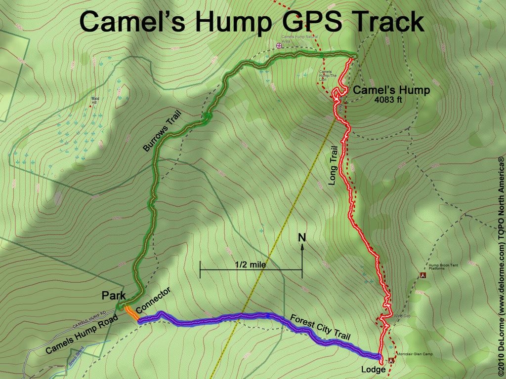
Camel's Hump can also be hiked all year round, making it a very popular winter hike. Even in the middle of February, you can still find 20+ cars at the end of Camels Hump Road at the Burrows Trailhead. The Burrows Trail is the popular route in the winter and because of it's popularity, it is well packed down, easy to navigate and the only route I can safely suggest for you to tackle in a winter with heavy snowfall.
Looking at the back of the map in the yurt, the State Park guide/map has a list of trails with marked distances to the summit and includes a list of popular routes. First on the list was the counterclockwise loop hike to the summit via the Long Trail and Burrows Trail. To me, any loop hike beats an "out and back" hike and I was excited to ditch my original plan of the Burrows Trail and hike this loop up the famous Long Trail to summit Camel's Hump. What I did not take into consideration was A: the conditions and B: the (lack of) popularity of this loop in the winter.  |
| Marissa following the Long Trail North to the Summit |
Turns out, Vermont had received over 3 feet of snow in the past two weeks and this particular loop to the summit is often only done in the summer months. This meant that our hike to the summit wound up being through deep snow up to our knees (and a few times our waist). Hiking up 2,000+' is a great hike and a solid workout. Hiking up that elevation with an unprepared group in a lot of snow where the trail is hard to find.... brings forth its own set of challenges. Morale was especially low when we finally came to a clearing and after several hours and a lot of post holing, the summit still looked so impossibly far away (note- it is never as far as it looks).
Everyone was wet, cold, and exhausted from hiking through that much snow without the proper gear. Needless to say, we were not prepared for that kind of snow. If we had stuck to the Burrow's Trail our microspikes would have been the perfect tool for the hike. If you want to hike the Long Trail Loop to the summit in a heavy snow year, you will need snowshoes, a compass, someone familiar with the trail, and a good map. This loop is not often traversed in the winter months and the white blazes on the snow covered trees are hard to find. Needless to say, a "quick hike to the summit" turned into an all-day event post holing and struggling through some deep fresh snow, all while the melting snow from the tree tops rained down on us.
I certainly started to feel insanely responsible for leading the group on a hike we were not prepared for. While my initial instinct was to turn around to the trail I knew would lead me back to the trailhead, I am glad we all listened to the most experienced hiker in our group to continue on to the summit to access the much easier Burrow's Trail. Albeit wet cold and exhausted, 6 people and 3 dogs safely and successfully made it up around and down this hike. And let's be honest, what is a birthday weekend without a few tears and a lot of laughs anyway.
 |
| The Long Trail- This was on the trail and at times we were struggling to get through the knee to waist deep snow |
Advantages: We had the trail to ourselves (we only saw 2 other people over the course of nearly 4 miles). The distance was longer (adding about a mile) which made the 2,000' gain a little easier. Lastly and most importantly, we were able to hike up a section of Vermont's famous Long Trail and hike with gorgeous views on the top of Vermont. Burrow's trail offers a popular trail that is well packed down, with a lot of other people, less mileage, but virtually zero views until you get to the summit. The views we saw making our way to the summit were breathtaking and hard to capture on film or in words.
 |
| Caution Sign on the Long Trail |
 |
| False Summit- First set of amazing views along the Long Trail |
 |
| Views from the summit of Camel's Hump |
 |
| Continuing on the Long Trail past the summit to head down the Burrow's Trail |
Distance: 5.6 miles as a loop, 4.8 miles up and down Burrows
Elevation: 4,083 feet
Prominence: 1,860 feet
Elevation Gain: 2,200 feet
Parking/Fee: There is no fee to access Camel's Hump State Park or the trailhead. However, this is a very popular trail and I recommend getting there early as the lot fills up quick. There are two lots and this is the one you want, the last one at the very end of Camel's Hump Road. When we arrived around 11 on a sunny Saturday, the lot was full and everyone was parking along the road.
 |
| Camels Hump Road Parking Area |
 |
| Entrance Map at the Burrows Trailhead |
Trailhead: Camels Hump State Park. At the end of Camels Hump Road where the Burrows trail starts.
Coordinates: 44°19'10.37" North 72°53'10.78" West
Rating: Moderate to Difficult
Dogs: Yes! Allowed off leash until the summit. Leash your dog at the summit due to the fragile alpine ecosystem.
 |
| Maverick making his way down the trail |
 |
| Amazing views from the Long Trail North |
Suggested Routes: 1. Burrows Trail (Most popular trail and the quickest way up/shortest distance but no views what so ever). Best bet in the winter.
2. The Long Trail "loop" which runs up and over Camel's Hump and offers gorgeous views but can be difficult to traverse in the winter. (See My Hike below for more route information).
Notes: Camel’s Hump’s summit is home to fragile alpine vegetation and hikers are reminded not to leave the trail and stay within the marked areas.
Features: 4,000' Summit, Long Trail, plane crash site.
 |
| Source: Loop Hike up Camel's Hump |

Long Trail South signage

 |
| Microspikes are needed to traverse the well packed Burrow's Trail |
 |
| Snowy Vermont landscape/ trail to the summit |
The summit offers great panoramic views in all directions. Views include Mount Mansfield to the north, Lake Champlain and the Adirondacks to the west, and many valleys and lesser mountain ranges to the east, possibly even as far as Mount Moosilauke in New Hampshire.
 |
| Crossing a bridge in a beginning section of the hike. |

1. Connector to Forest City
2. Forest City to Long Trail: 2.2 Miles
3. Long Trail to Summit: 1.7 miles (2.74 kilometers)
3. Long Trail to Summit: 1.7 miles (2.74 kilometers)
4. SUMMIT
5. Long Trail to 4-way Trail Intersection (Burrow's): 0.3 miles (0.48 kilometers)
5. Long Trail to 4-way Trail Intersection (Burrow's): 0.3 miles (0.48 kilometers)

 |
| Hiking up the Long Trail |
- You are only as fast as your slowest hiker. It can be really tough when one pace is set and people in the back are having a hard time.
- Fuel often: This was a big issue. We were hiking at a fast pace and were not taking the time to hydrate and refuel. Some sugar and water are vital for a clear head and good decisions.
- Take a break to think - Again, this is kind of a summary of the two points about but hiking at one pace does not work. We needed more breaks to sit down, refuel and think clearly.
- Do more research and check trail conditions. A good idea is somewhere like instagram where you can see recent trail pictures. Also, check snow reports.
- Make everyone carry their own bag with extra supplies. If everyone doesn't carry a bag then most likely you do not have the room for extra layers. Also, put extra layers in a bag in case your bag gets wet from the snow and snow melt raining down. Extra gloves are important, and maybe even some bags to put in your boots to keep your feet dry.
- Proper gear: Gaiters and snowshoes were necessary for this hike.
- Attitude and Experience are important: The right attitude was 100 percent necessary on this hike. Again I am super thankful we had Ben who kept a positive outlook and had the experience to make the best decisions to get the group up and off the summit before nightfall.
 |
| Thatcher on the snowy trail |
 |
| Forest City Trail to the Long Trail |
 |
| Hiking the Long Trail to the summit |
 |
| Turn onto the Long Trail, 1.7 miles to the summit |
As always, my goal with these posts is to give you all the information you need for a fun (and safe) hike. The trail info section of this blog started with my hike to the Timpanogos Summit when I was so frustrated with conflicting statistics or a lack of information on some of these trails.
All in all, this was a gorgeous winter hike that came with its own unique set of challenges and rewards. Due to the snow pack, this ~6 miles hike was much more challenging. Being prepared with the right gear for the current conditions is key. Despite the conditions, it was great to have the trail to ourselves, and the gorgeous views of snow topped Vermont. We all had a blast and can look back and laugh at some of our not-so-proud moments. I will definitely be back in the summer to hike this loop in the warmer months and hopefully hike a longer section of America's first true Long Trail. Thank you Vermont for another beautiful day in the mountains.
 |
| Overlook along the Long Trail |
Thanks
ReplyDeleteI am new to winter hiking and I definitely need lots of tips to help me survive in the cold. Your blog has really been helpful. Thanks for sharing. I also found some exceptional winter backpacking ideas here: http://wildernessmastery.com/outdoors/winter-backpacking.html
ReplyDeleteThanks
ReplyDelete