

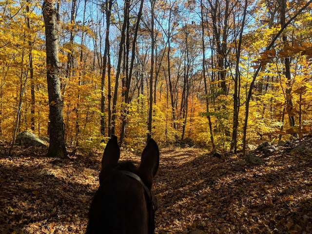
I used to say I would love to live on a trail system - someday. That day came in 2020 and yes, I pictured something a little more... mountainous than Old Saybrook in Coastal Connecticut. There aren't any big summits or impressive vistas but there are miles and miles of quiet trails that are connected through several different trail systems. All available from the end of my street.

I started writing trail guides in Utah when misinformation turned an 12 mile hike into a nearly 15 mile hike. Conflicting and downright wrong information left me insanely frustrated as I tried to prepare for a hike. One of my favorite trail systems here in Connecticut (where you can hike/bike/ski/horseback ride) also suffers from a lack of information. I can't tell you how many times I have tried to point a lost hiker in the right direction, or listened to stories of my neighbors driving hikers back to their car on the other side of town. The preserve is an awesome trail system that is fairly new and there is a lot of ongoing effort to update the maps and trail system. The preserve also neighbors other trail systems in town/adjacent towns.
The Preserve combined with the Great Cedars Conservation, Clark Community Park and Essex Meadows/East Preserve, means you have even more trails and ways to connect. The problem? First off, there is no one map that connects them all (until now). Second, there are so many unmarked trails in the preserve and it's really easy to get confused. Ashley of The Well Dressed Table solved both of these issues by combining all the maps into one and then adding all of the unmarked trails in purple. You can now see nearly every trail through the Preserve, Essex Meadows, Clark Park and Great Cedars all on one map. I have a 5x7 copy laminated with a clip that I can clip onto the dog's leash and bring out with me on a hike. You can find a copy to blow up or shrink to as small as you need here.
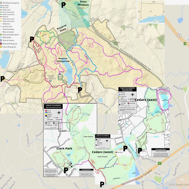
Combined Map of The Preserve, Essex Meadows, Clark Park, Cedars (east and west)
including all parking areas (P).
a b o u t
The Preserve was the largest remaining unprotected coastal forest between Boston and New York before its acquisition for conservation. Seventy acres in Essex are owned and managed by the Essex Land Trust with the majority of the remaining acreage jointly owned by the state of Connecticut and the town of Old Saybrook. Because different parts of the preserve are managed by different entities, there are different maps and even more confusing, different rules regarding dogs and bikes in the preserve (see dogs and bikes section towards the end of the post and within each individual park description). The Old Saybrook and Westbrook sections of the preserve allow dogs on leash and bikes on all of the trails.

The Official Preserve Map (not updated with all of the unmarked trails)

Modified Preserve Map with Unmarked Trails in PURPLE

Essex Section of the Preserve
The Preserve (Essex)
The northern portion of the preserve lies within the boundaries of the Town of Essex and this section is managed by the Essex Land Trust. The Essex Land Trust map section of the Preserve trails states "Dogs are welcome but must remain under the control of their owners". Bikers are also only allowed on the utility road in the Essex section of trails.
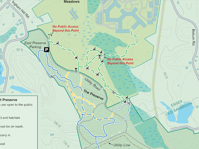
Essex Meadows and Essex Section of the Preserve
Essex Meadows
The northern section of the Preserve in Essex also connects over to Essex Meadows/East Preserve. This is a small trail system but a pretty one with meadow views, streams, and benches throughout the area. The Essex Meadows map states dogs must be on leash. Bicycles are only allowed on the utility road.

Clark Community Park Trail Map
The Southwest section of hiking trails on the combined map is the "Clark Community Park" trails. They start at the Clark Community Park in Old Saybrook (here you can find baseball fields, a pond, and a picnic/grill area). There is a small loop on the west side of the lake that also connects over to Kitteredge Hill. The trails on the east side of the lake head north to a blue/red loop system which connects to the Preserve, or south along the red trail and connects to Great Cedars Conservation Area. Dogs are allowed on leash and bikes are allowed on all trails.

Great Cedars (West) Trail Map

Great Cedars (East) Trail Map
Great Cedar Conservation Area (East and West)
Great Cedar Conservation Areas (East and West) connect to the southern/southwestern part of the preserve. The western section is accessible off Ingham Hill Road and travels through the Cedar Swamp. You can cross Ingham Hill to access the trailhead for the eastern section. The eastern section is accessible off of Merrit Lane off Ingham Hill and has a smaller red loop and also larger loops around Lower Ingham Pond and Upper Ingham Pond (shown on the bigger/edited map). The eastern section gives you access back to the preserve.

There are several parking areas to access the different parts of the preserve. The largest/most developed lot is in Westbrook and includes horse trails parking area. The other areas are small and offer limited parking.
The Preserve Parking
WESTBROOK: 1278 Essex Roads/Plains Road (Route 153) ** Horse Trailer Parking
OLD SAYBROOK: Interim Parking Lot across from #243 Ingham Hill Road
OLD SAYBROOK: Interim Parking Lot across from #243 Ingham Hill Road
ESSEX: East Preserve Parking Lot- Ingham Hill Road, enter from Rt. 153.
ESSEX: West Preserve Parking Lot - Ingham Hill Road, enter from Rt. 153.
Other Parking Areas
There is a large parking area at Clark Community Park that provides access to those trails.
There is a small parking area off of Old Back Highwy off of Schoolhouse Road that provides access to Great Cedars west.
There is a small parking area along Ingham Road by Chalkers Mill Pond that provides access to Great Cedars West
There is a small parking area off of Merrit Lane (off of Ingham Hill) that provides access to Great Cedars East
There are several small neighborhood trails (Beaver Dam, Kitteredge, etc) that provide access to the trails but DO NOT have parking areas.

a c t i v i t i e s
What can you do in this amazing trail system we go into a ton of detail below? You can HIKE, MOUNTAIN BIKE, WALK YOUR DOG, RIDE YOUR HORSE, BIRD WATCH, CROSS COUNTRY SKI, SNOWSHOE, TRAIL RUN. What you cannot do is ride any type of motorized vehicle through the trail system (quads, dirt bikes, etc). I have seen both in the preserve at different times and not only are they destructive to the trail system, but they are very dangerous to pedestrians, dogs, and horses enjoying the trails.

n e e d t o k n o w
I urge you to bring a copy of the map with you - digital fine, hard copy preferred. There are some maps at major trailheads but do not depend on these to get you through the preserve or the adjacent trails. Also understand that there are a lot of unmarked trails through the preserve (not on their map, but on the one we created in this post). If you come across some newly established single track - please do not follow it. Mountain bikers and hikers seem to be making some additional trails throughout the park. Please only follow established trails throughout the park.

d o g s
Different parts of this system have different rules. Dogs are allowed on leash on all of the above-mentioned trails. Dogs are allowed under the owner's control on the Essex portion of the trail.
b i k e s
Different parts of this system have different rules. Bikes are allowed on all of the trails in the Old Saybrook and Westbrook portions. Bikes are only allowed on the access road in the Essex portion of the trails.

w i l d l i f e / c o y o t e s
I have seen a lot of wildlife in the preserve. I have seen turkey vultures, hawks, owls, a fisher cat, deer, lots of birds and frogs, and even a coyote. The coyote population is thriving in the preserve and they do not appear to be frightened by hikers or their dogs. I have heard reports of people's dogs being attacked in the preserve. My sister had one follow her and her dog for quite a bit. I had one turn around and start to follow me and the dogs on a trail. They are most prevalent at dawn and dusk and hunt at night.
Preventing Coyote Interactions
Make Noise - Coyotes tend to avoid humans and the best way to prevent an (accidental) encounter is to avoid a surprising one. Hike with others in a group or play music/wear a bear bell.
Keep Your Dog on a Leash - Coyotes will go after your dog and most coyote attacks involving humans have been the result of attacks on pets in which the owner tried to intervene.
Should you come across a coyote on your hike, the most important thing to do is never turn your back on it and don’t attempt to run from a coyote (they can run at an average speed of forty-two miles an hour). Also, DO NOT pick up your dog. What you SHOULD do is stand your ground and maintain eye contact with the animal. Unlike bears, wolves, and mountain lions, coyotes can be intimidated, and most times simply standing your ground will be enough to send the coyote on its way.


Happy Hiking
No comments :
Post a Comment
Let's Chat!