If you've been following along on KW the last few years, you probably know about my New England Summit Tour. When I moved back to New England from Utah (the land of mountains majesty and excellent hiking), I made a vow to take that sense of adventure I learned out west and apply it here in the Northeast. Our peaks may not be as prominent, but we still have some impressive mountains to climb. My start to an Elevated New England was to hike all the New England summits. I vowed to take my hiking boots up the summits of Connecticut, Massachusetts, Maine, Rhode Island, New Hampshire and Vermont, camping hiking (and drinking) my way from Jerimoth Hill in Rhode Island to Katahdin in Maine.
 |
| Hiking Bear Mountain in 2016 |
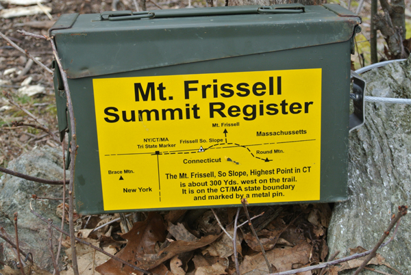
High points are straight forward in most states as the highest point is generally on top of the highest peak. Connecticut gets a little technical where you have the highest summit - Bear Mountain and the highest point - the slope of Mt Frissell right before the Massachusetts border. On my New England tour, I decided to do the summit instead of the high point because standing on top of Bear Mountain sounded a lot more appealing than standing on a slope at the MA border. Summit is just a little sexier, isn't it? But if we are being technical (which today, we are) the high point is down the road on Mt Frissell's South Slope.
 |
| On the Red Trail to Mount Frissell |
So what promulgated my return back to the northwest corner for another hike in the Quiet Corner of Connecticut? It wasn't the technicality but instead, a chance to hike with and support a friend on his high point tour. Katie Wanderers, meet Chris over at The Bold Nomad. I met Chris through the world of bloggers, and our love of the outdoors and status at New England Natives living out west (he in Colorado and I in Utah - both back in New England for now) was the basis of a trail filled friendship. After walking from Mexico to Canada on the Continental Divide Trail, Chris moved back to Vermont to work and build his Sprinter Van before taking off for his high point tour. On his cross country journey from Colorado to Vermont, he stopped in Guilford for some lower New England fun. The problem? When you find a Vermonter living in Colorado, you won't impress them with Connecticut mountains or hikes so instead, I showed him some of my favorite spots along the Connecticut Rhode Island Coast (breweries, bars, and beaches... oh my!).
While back in November we were eager to sip beer and break bread, I was excited for the chance to "break trail" with Chris and join him on a few summits for the highpoint tour. And so, my journey back to the center of the earth highest point in Connecticut was born.
 |
| Creek crossing on the way back to the trailhead |
So - about the hike. While this hike will give you the authority to say "I stood on the highest point of Connecticut" it's really not the highlight of the hike (Bear is really more interesting for this). What is the highlight you ask?
- Being able to cross three states in one hike
- Being able to hike three different summits in three different states on one hike
- Beautiful views from several spots
- A good workout, an interesting loop hike, and some solidarity (not too popular!)
So now you know the why, let's briefly discuss the when. Chris is also a planner so we whipped out our Google calendars and decided the end of April was going to be our shot at the summits. If you are familiar with the weather in New England, she's a real moody bitch and it can be humid one day, rain the next, and maybe snow later that day. It's hard to predict, it's hard to plan. What can you do? Commit to the date and plan accordingly. Easier said than done when you are clicking "okay" on your google calendar mid-February. A little tougher three days out when the forecast calls for rain all weekend with a chance of snow. Old Katie? She would push this off, struggle to find another weekend, and likely never end up doing the hike. Current Katie? She placed an order online at REI for local pickup for a cover for her backpack and a set of rain pants.
 |
| Caught in the snow towards the end of our hike |
I read a fantastic article that Thursday as I packed up my gear (extra socks, raincoat, rain pants, microfiber towel, and extra mid layers included). It's called "In Praise of Going Out No Matter the Weather" and is published on Outdoor Research. Highlight reel: It's close-minded to look at the weather as "good" and "bad", it all just depends on your attitude and how prepared you are. Don't let the weather deter your motivation as some of the best stories happen when the weather isn't exactly as you planned.
 |
| Chris at the Connecticut High Point |
 |
| Connecticut High Point |
So weather aside, we set off on our hike, our cars parked on the Connecticut/Massachusetts border after a long detour with a failed attempt at the Connecticut side (the dirt road is closed and there is no access in the winter months - or before May I suppose). After turning around, driving up through Massachusetts and back down from that other side of the trailhead, the cars were parked and the thermostat read a crisp 38 degrees. Because of the cool temps and threat of rain (and snow) on the forecast, we only saw two other cars at the trailhead and a few groups of hikers on the trail, all smiling through the chilly temperatures and snow flurries as we made our way from Connecticut, into Massachusetts, through New York and back.
 |
| Red Trail in Connecticut |
To start, follow the Red Trail (Mr. Frissell Trail) on the MA side of the border. Rather quickly into the hike, you start to climb in elevation and in the first 1/2 mile, you have reached your first summit, Round Mountain in Connecticut. From there, continue on the red trail into Massachusetts where you head out on an offshoot to summit Mt Frissell. Heading back to the main trail, keep following the red blazes as you enter back into Connecticut and hit the Connecticut high point on the south slope (it's literally just the last section of trail in Connecticut on this trail heading to higher Massachusetts, pretty underwhelming. After leaving the highpoint, you will travel along the CT/MA border until you reach the corner where the CT, MA and NY all meet (you will see a pillar marking MA and NY, CT somehow was left off). Follow the red trail to the end where you will hop on the white trail south to the summit of Brace Mountain.
From there, backtrack your steps to where the red trail ends and look for a trail heading right (east). It is unmarked, unnamed, and not really on the maps. Now that you know what it is not, I can tell you what it is: its a stream bed turned trail and in the spring it is a stream you are hiking through - now known as Katie Creek. After the first half mile, I surrendered to the weather and embraced the idea of wet shoes, knowing I would have a few hours to dry my boots in the car before our trek into camp and plenty of dry socks and plastic bags to make the rest of the trip work. The Katie Creek trail eventually joins back up with the dirt road (you know, the one that is closed in Connecticut that I couldn't drive) and you simple hike a mile back up the dirt road to the MA/CT line where you left your car.
After 5.4 miles and 1,078 feet of elevation gained, you earned some nachos and a beer (my favorite post-hike treat). Three states, three summits, pretty views, and a high point - all hiked in a loop. What's not to like? I highly recommend this hike if you are looking for something a little different and a little interesting when Bear Mountain is a little too crowded.
High summit, high point, I have now stood on both. COme for the high point glory, stay for the three states and three summits.
 |
| Parking area at the MA/CT Line |
 |
| Round Mountain, CT summit |
 |
| Mount Frissell, MA summit |
 |
| Tri-State Marker |
 |
| On the South Taconic Trail to Brace Mountain |
 |
| Brace Mountain |
 |
| Views from Brace Mountain |
 |
| Snow on the trail |
 |
| Red Trail coming back from the Connecticut High Point |

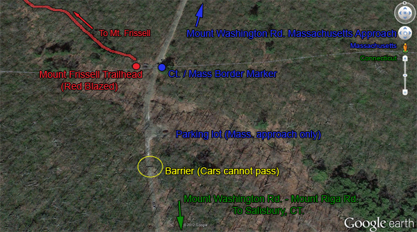
**Google maps will reroute you through MA in the winter as the road is closed (jersey barrier kind of closed). In the summer, you can force it to Salisbury to Riga Road and then Mount Washington Road (map below) which is the route from the south. In the winter, the only accessible trailhead is through Massachusetts.
From the south: In Salisbury, Connecticut, go west on US 44 and then turn right on to Factory St. Shortly thereafter, you should bear to the right onto Mt. Riga Road. Mt. Riga road eventually turns into a gravel/dirt road and continues a couple of miles to Mt. Washington Road. Turn right onto Mt. Washington Road, and go 3.3 miles to the AMC parking lot on the right.
From the north: However, if you are traveling from Massachusetts, or after November and before Mid May, you need to go the long way (from the north) up into Massachusetts and back down into Connecticut. The access is via Route 7 to Egremont Road to North Undermountain to Washington Road (the dirt road). It can also be very rutted out in winter although we had no issues (Mazda CX5 and sprinter van) at the end of April.
Regardless of the entrance, you have taken, from the north or the south, follow the dirt road to the Connecticut/Massachusetts border. Directly across the street from the road sign and border marker is a small grass parking area. Red paint marks note the trail to Mt. Frissell. A short distance after you begin hiking, the trail turns left...keep your eyes open and follow the red markers to the left and don't continue straight.
No bathrooms, no maps - come prepared
There is a small lot that fits about 3 cars, and just up the road another small lot
(AMC lot) that fits about 5-6 cars).
 |
| How you reach the trailhead in the winter/before mid-May |
The only way to access the trailhead when the dirt road is closed (closed at the CT/MA border and then further into Connecticut at Riga Road
 |
| CT access - summer only |
Access way in the summer only via the CT side (Riga Road to Mount Washington Road). It was closed at Riga Road when we went the last weekend of April, meaning we had to trace our steps and go up into MA and back to the CT border
Distance: 5.4-miles loop (1 mile of it is on the dirt road on the way back)
Elevation Gain: 1,078'
Starting Elevation: 1,373'
Max Elevation: 2,451'
Summit Elevations: Round Mountain (2,289'), Mt Frissell Summit (MA summit, 2, 453') Frissell South Slope (CT high point - 2,380'), Brace Mountain (2,311')
- Start at the trailhead off Mount Washington Road and follow the Red Blazes
- Hike 0.5 miles to the summit of Round Mountain (2,289')
- Continue 0.5 miles to Mt Frissell Summit (MA summit, 2, 453')
- Continue 300 yards to Frissell South Slope (CT high point - 2,380')
- Continue 0.5 miles on red trail NY/CT/MA tri-state marker end of red blazed trail - It's about 2.2 miles from trailhead to terminus of Red Trail (tri-state marker)
- Hop on the South Taconic trail (white blazes) and continue 0.4 miles to Brace Mountain, New York (2,311')
- Return back the 0.4 miles to trail junction where the red trail ended and cut east on the trail leading back to CT (Katies Creek....)
- Follow the trail to Mount Washington Road
- Walk the road about 1 mile back to your car
Happy Hiking Wanderers,


No comments :
Post a Comment
Let's Chat!