Search This Blog

Tuesday, March 24, 2015

Motivational Monday 3/9 to 3/15, 3/16- 3/22


Time for an update! 
 Motivational Monday was pushed aside due to Zion recaps. 
 SO today we are reviewing the past two weeks:

Monday (3/9):     REST
Tuesday (3/10):    4 miles 
Wednesday (3/11):    REST
Thursday (3/12):    3 miles 
Friday (3/13):     Zion- 9.5 miles hiking
Saturday (3/14):     Vegas 
Sunday (3/15):    Drive- 2 mile hike 

Monday (3/16):    4 miles
Tuesday (3/17):    11 miles
Wednesday (3/18):    Riding 
Thursday (3/19):    Trail ride Antelope Island 
Friday (3/20):    3 miles & Riding 
Saturday (3/21):    Ski
Sunday (3/22):    7.5 mile hike 

ADVICE:   If there is one thing I can try to "teach" you, it is that do not sweat the runs you missed.  Really, your number one concern should be getting your long run in at any cost.  With the weekend spent in Zion, I had to push my long run to Tuesday morning.  No, I did not do it at the scheduled weekend slot but yes, I still got it done.  You can be shady about your short runs, but do not miss a long one!


Thursday, March 19, 2015

Riverside Walk, Entrance to The Narrows, Zion National Park


Riverside Walk / Entrance to The Narrows Zion National Park, Utah 


Riverside Walk, Zion National Park, Utah 


The Riverside Walk Trail was a great way to end our day at Zion National Park in Southern Utah.  Riverside Walk is the 2 mile out and back paved trail that leads to the entrance of The Narrows.  The trail head is at the Temple of Sinawava, which is at the very end of the Zion Canyon Scenic Drive (the 6 mile road through the park where are the trail heads are).  

Riverside Walk Map, Zion National Park 


Riverside Walk, Zion National Park 

The paved trail is one mile out to the end, following the Virgin River to the start of The Narrows.  There are portions where you can leave the paved trail and walk right along the river with your toes in the sand.  It is much cooler here than the other sections of the park and the water is quite cold this time of year.  

Virgin River, Riverside Walk, Zion National Park

Riverside Walk, Zion National Park

This is a gorgeous trail for all types of hikers, and a great option for anyone looking for an easy hike on a paved trail with gorgeous views along the Virgin River. 


Riverside Walk, Zion National Park

Riverside Walk, Zion National Park

Riverside Walk, Zion National Park

Virgin River, Riverside Walk, Zion National Park

Virgin River, Riverside Walk, Zion National Park

We started this trail at around 5pm and saw a ton of hikers, a bunch walking back from The Narrows in their dry suits and hiking sticks.  Although hiking The Narrows in the winter requires a $40 dry suit rental, you get to enjoy a less crowded hike in one of the most beautiful and popular sections of the park.  I fully intend to head back to Zion to hike the famous Narrows and can’t wait to tell you all about it then. 

Hikers in dry suits at the entrance to The Narrows, Zion National Park

Hikers in dry suits at the entrance to The Narrows, Zion National Park

The Narrows starts right here, where the Riverside Trail abruptly ends and the only way to continue is, you guessed it, right through the river.  


This is how I spend most trips, with a Go Pro or camera in front of my face. 

Riverside Walk, Zion National Park

If trudging through the river for 8-12 hours, or even over night isn't your definition of the best hike ever, or the weather won’t allow, the Riverside Walk is a great way to see the beautiful Virgin River and the opening of The Narrows.  


Wednesday, March 18, 2015

Angels Landing Trail, Zion National Park

Angels Landing Trail
Zion National Park, Utah 

5 Miles round trip to the edge of Angels Landing
4 Miles round trip to Scouts Lookout (before the chains)


Trail head: Grotto Picnic Area 

Angels Landing Rock Formation: 1,488-foot (454 m) tall

Elevation at the top of Angels Landing: 5,790 feet


View of Angels Landing from the parking lot, Zion National Park

Angel’s Landing is one of the most famous and iconic hikes in Zion National Park. Angels Landing and The Narrows are usually the most talked about hikes, and find their way to the top of everyone’s MUST Hike List. 

Why? 
The challenge.
 The first 2 miles of the trail are hard work, but the last 1/2 a mile is for thrill junkies only.

Angel’s Landing is the high, steep cliff face overlooking Zion Canyon. "While exploring what was to be present day Zion in 1916, Fredrick Fisher proclaimed “only an angel could land on it” and consequently the monolith was named Angel’s Landing" Source


Virgin River, Zion National Park
To start, you will cross a bridge over the river, and head up the paved trails.  The trail starts out  relatively flat but starts to switch back up the steep trail quickly.

Insanely gorgeous view down the canyon from the Angels Landing Trail, Zion National Park

Soon you are rewarded with this view down the canyon. I could spend the day here it was so insanely beautiful. The trail will head up some steep switchbacks until you reach Refrigerator Canyon. This canyon is a nice flat(ish) paved trail, between the canyons where the temperature drops, and the shade is a nice relief. 


 After leaving this canyon, you head up again and approach Walter’s Wiggles, the very steep switchbacks leading to Scouts Lookout and the section of the trail where the chains start. Walters Wiggles are a serious glute workout (21 switchbacks), I promise! After Walters Wiggles, you reach the start of Scouts Lookout. Here you will find some bathrooms, as well as a lot of people waiting for their friends and loved ones to make it back from "the chains".


Refrigerator Canyon, Zion National Park


Walters Wiggles, Angels Landing Trail, Zion National Park


This is the spot where I enjoyed a cold beer, and watched the hikers leave nervous and excited, and come back either feeling accomplished or in tears (a whole lotta tears).
First views of the chain section of Angels Landing Trail, Zion National Park
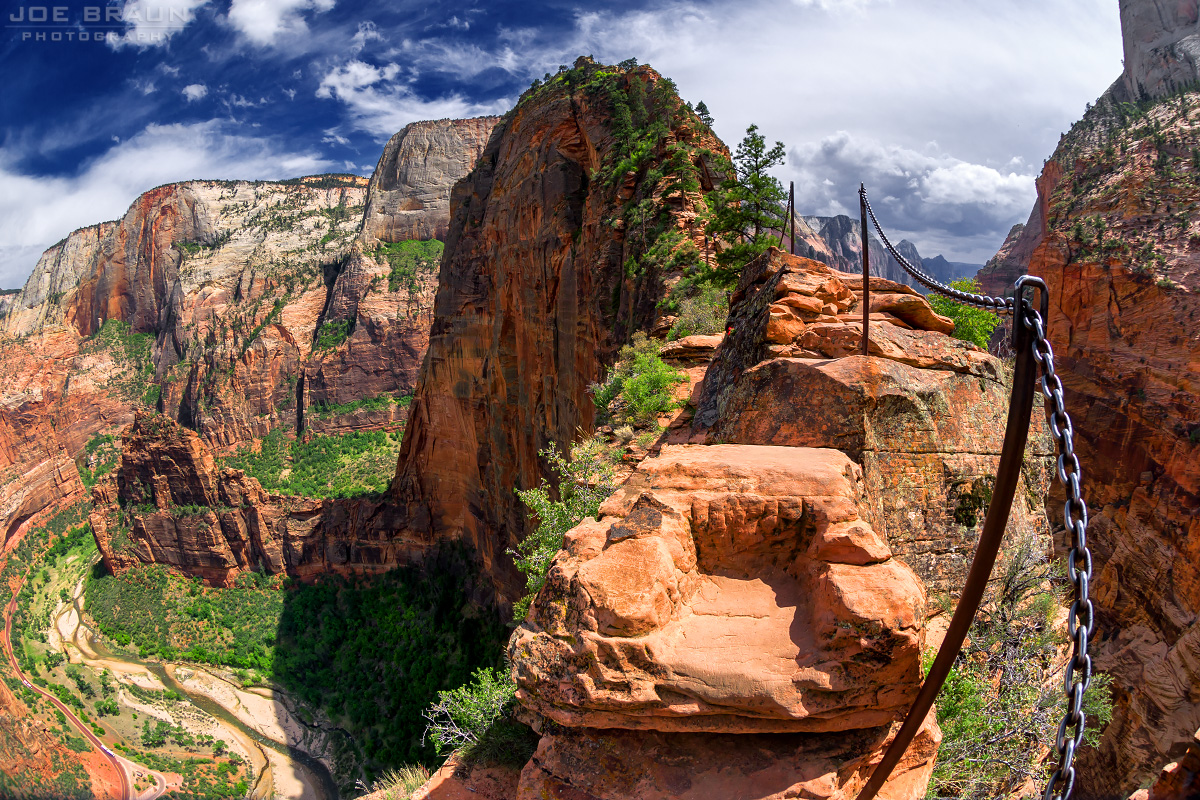
The hikes claim to fame is the last half a mile of the hike, where the paved trail ends, and “the chains” begin. The last half mile of the hike is up the rocky spine of Angels Landing. A set of poles and chains runs through the middle of this half mile stretch.


The easy beginning of the chains on the Angels Landing Trail, Zion National Park

If you are not a fan of heights like me, you can still enjoy a hike to Angels landing up to the point where the chains start, known as Scouts Lookout or “Quitters Corner”. The trail up until this point is a challenge, with steep climbs and large drop offs, but with the actual comfort of the trail. 
Scary part of Angels Landing I did not make it to- "Leap Of Faith"- 1000' drops on a 2' trail
Angels Landing photo (Zion National Park) -- © 2007 Joe Braun Photography
The view from the very edge of Angels Landing. 


The trail gets as narrow as 2' in some spots, with 1,000’ drops on each side. The only thing keeping you plummeting to your death is steady foot work and a firm grasp of the chain. Not only is the trail narrow, with 1,000’ drops, but it is a verrrry popular trail with a lot of traffic, and a lot of people pulling on that chain in front of you and behind you. 


No. Thank. You. There have been a few deaths at this section of the park. But when you compare it to the thousands of people who use this trail, it really isn't common. Just make sure you have some steady foot work. If you have any fear of heights, they recommend you stop at Scouts Lookout.  Eight Reasons you shouldn't hike Angels Landing.


Warning signs at Angels Landing Trail, Zion National Park

Canyon Views, Angels Landing Trail, Zion National Park
If this does not sound like your cup of tea, don’t worry, you can enjoy the hike up until this point. The views are phenomenal along the entire hike. Do not let this trails history/talk scare you away. The views are spectacular and you can still experience amazing views up until Scouts Lookout.
Heading back down the Angels Landing Trail, Angels Landing Trail, Zion National Park
          
Steep drops and gorgeous views, Angels Landing Trail, Zion National Park

Canyon Views, Angels Landing Trail, Zion National Park
Steep climb on the Angels Landing Trail, Zion National Park
End of the trail, the Virgin River, Angels Landing Trail, Zion National Park
The hike back down is gorgeous, with more astonishing views. If you only make it to quitter corner, you are still enjoying a gorgeous 4 mile hike, with some serious incline and view for days. Power to you if you make it all the way to the landing, and a high five if you only make it to Quitters Corner like me ;)

Avoid this trail in icy conditions, and in the summer, 
make sure you start before the heat sets in. Good Luck!

Tuesday, March 17, 2015

Lower and Upper Emerald Pools Hike, Zion National Park

Lower and Upper Emerald Pools Hike

Our first hike at Zion National Park was the Emerald Pools.  
The combined hike to the Upper Emerald Pool and back is about 2.2 miles round trip.  

Zion Lodge, Zion National Park
The trail is accessed via the parking area/shuttle stop at Zion Lodge.  From the Lodge, it is a 0.6 mile hike to the Lower Emerald Pool trail.
Bridge at Emerald Pools Hike, Zion National Park
 The trail is paved and is a beautiful easy hike viewing natural pools and waterfalls.  From here, you can hike an additional 0.5 miles to the Upper Emerald Pool trail that is rock and sandstone. 
 The trail ends at the upper pool with a small waterfall. 

Waterfall at Upper Emerald Pool, Zion National Park
Upper Emerald Pool, Zion National Park
 Unfortunately, the pool was more brown than emerald, but this was a beautiful hike none the less.  The Lower Emerald Pool was definitely my favorite, where the trail curved around this waterfall area.

Waterfalls at the Lower Emerald Pool, Zion National Park
 Where the Lower Emerald Trail ends and Upper Emerald Trail begins, the Kayenta Trail starts.  The Kayenta Trail connects the Emerald pools section to the Grotto area, the trail head for Angels Landing.  If you wanted to extend your hiking, you could hike the Lower Emeraly Pool, the the Upper Emerald Pool, and then back to the Kayenta Trail connecting over to the Grotto and Angels Landing.

Waterfalls at the Lower Emerald Pool, Zion National Park
This trail is very popular and very busy (and full of hikers of all abilities).  It is narrow in parts which makes it a little congested and frustrating if you are stuck behind large crowds.  I was really amazed how busy and warm the park is in March, and really can’t picture being here with much larger crowds and warmer temperatures.  I will say the serenity of the park was sometimes lost due to large and rowdy college kids visiting for Spring Break.  Regardless, this was a great trail to hike out to and enjoy the scenery.    

Emerald Pools Trail, Zion National Park 
Emerald Pools Trail, Zion National Park
Virgin River, Zion National Park

Monday, March 16, 2015

Guide to Visiting Zion National Park

Zion National Park

Utah's first (and busiest!) National Park.  


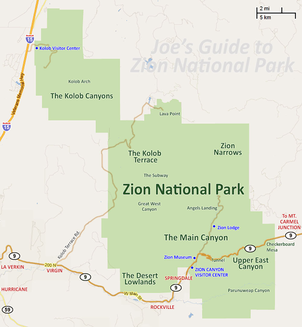
Friday morning, we packed up the car around 5:30 am and were out the door by 6 am.  The plan was to head South down I-15 and in Southern Utah cut East and come into the park from the opposite end.  This was a good way to drive a “loop” around Zion instead of heading straight down 15,up the Canyon road, and back the way we came. 


(Take the route not highlighted- coming into Zion from the east and through the tunnel). 
This allowed us to come through the Zion/Mount Carmel Tunnel, drive up and down the National Park Canyon Road, and then out a different way we came.  I think the mileage is pretty similar for both routes and may add a little extra time (worth it!).  We got to Zion around 11:00 am after a stop or two along the route.  It was a gorgeous sunny day in Southern Utah.


(All information taken from the National Park guides handed out at the park ranger station). 

When you come in this "other way", you come through the Zion-Mt Carmel Tunnel that connects Zion Canyon to the east side of the park.  There are a series of two tunnels, the larger/longer tunnel  built in the 1920’s.  If your vehicle is 11’4” high or higher, or 7’10” wide or wider, you are going to require one lane traffic control through the tunnel (nearly all RV’s, buses, trailers, fifth wheels, dual wheel trucks campers and boats require this traffic control at cost of $15 per vehicle- good for two trips through during a seven day period). 
 This service is only allowed November 2nd to May 2nd.  I recommend if you are in a large vehicle enter the park the other end (highlighted on the map) and avoid the tunnel altogether. 


It is a very long, very dark tunnel, with a few cut outs in the tunnel that allow for natural light.  Pedestrians and bicycles are NOT allowed in the tunnel because the lane is only wide enough for a car.  If you are walking or biking the road, you will need to catch a ride through the tunnel.  


From November 30th to March 14, the Zion Canyon Scenic Drive (the main road through the park where you access all trail heads)  is open to private vehicles.  Be warned, parking may be an issue on weekends on the popular trails when the shuttle is not in service. 

The rest of the season, March 15th to November 29th, you can only access the park through a shuttle system.   You will not be able to drive your car into the park.  The shuttle stops at all trail heads, lodges, and centers, and eliminates all those cars on the one Canyon Road and all parking issues.  Each full shuttle reduced traffic by 28 cars, reducing vehicle miles traveled per day by over 50,000 and reduce CO2 emissions by over 12 tons a day. 


The fee to get into the park is:  $25 per vehicle, or $12 per individual: pedestrian, bicycle, motorcycle, or organized group.  This gives you a seven day access for the park.  Other options include a Zion Annual Pass for $50, an Annual Pass to all federal fee areas for one year (what we did) for $80,  a Senior pass admission to all federal fee areas for LIFE (U.S. citizens 62 years or older) for $10, or an Access Pass to all federal fee areas for permanently disabled U.S. Citizens for free.  Our $80 pass will get us into all National Parks and National Fee areas for the year, which is a great deal if you plan to see a few parks over the course of the year (this is our 3rd National Park already!).

Need To Know:  Even in March, it was very hot hiking in the sun at Zion.  Sunscreen, sunglasses, hat, and plenty of water is a must.  Experts recommend one gallon of water per person per day.  Water is available via water pumps at the visitor center, campgrounds, Zion lodge, and other locations around the park.  According to the Zion newsletter, hypothermia is the number one killer of outdoor recreationists.  It gets quite cold at night in the desert and hiking in the Virgin River in the Narrows can be cold (immersion in water is the quickest way to lose body heat!). 


The Narrows is the famous hike in Zion National Park where you actually hike IN the Virgin River.  The gorge is 16 miles long and up to 2,000-feet deep, with some widths as narrow as 20-30’.  Atleast 60% of the hike is spent wading in water and depths can reach waist to chest deep.  Flash flooding in a major concern for this area.  A dry suit is needed in the winter and a walking stick is recommended at all times for the slippery rocks in the river bed.  There are three ways to hike which I will talk about in my trail post, but what you need to know is two of the ways to hike the Narrows requires a private shuttle and a permit. 


Wilderness Permits are required for overnight trips, through two of the ways to hike the Narrows, and any technical climbing, back country, or overnight trips.  Wilderness permit fees are based on the size of your group:  (10$ for 1-2 people, $15 for 3-7 people, $20 for 8-12 people).  To hike the Subway, the famous section of the Narrows, a permit is required.  40 permits are registered on a reservation basis and 40 are kept for first come first served trips.    
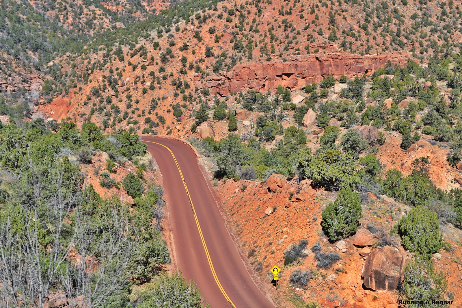
Alright, now you know the basics, and saw some beautiful pictures of the drive into the National Park.  Let's start talking about those iconic hikes!

(http://www.citrusmilo.com/zionguide/gettingaroundzion.cfm)

Most popular Zion Hikes 

Trail head:  Weeping Rock Parking Lot
Distance:  8 miles

Trail head:  The Grotto Picnic Area- Zion Canyon
Distance:   5 miles

Trail head: Zion Lodge
Distance:  3 miles


Riverside Walk 
(gateway to Narrows)
Trail head: Temple of Sinawava
Distance: 2 miles

Trail head: Immediately east of the Zion-Mt. Carmel Tunnel by the ranger booth. 
Distance: 1 mile

Pa'rus Trail (biking and dogs allowed)
Trail head:  Canyon Junction - The spur where the Zion-Mt. Carmel Highway and the Zion Canyon Road intersect. 
Distance: 3.4 miles